I’ve always had “a bit of a thing” for GPS devices, and have owned a dozen or more for different purposes – CF card receivers that plugged into Windows Mobile devices, a Garmin standalone device for hiking, a TomTom when I owned a car etc. Of course these days every smartphone has GPS built in – but as ever with such convergent devices, the battery life is the problem.
A few years ago I wanted to start geo-tagging my photos. Although a few more cameras now come with GPS receivers, it’s still not a common feature. But the way around it is to log your position every few seconds, and then use these data when you get home to tag photos with their position. The key thing here is to make sure that the camera has the correct time set, and then software interpolates between subsequent GPS points to find an approximate location for the picture, and writes these data into the EXIF header.
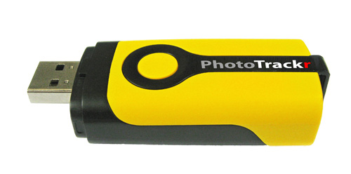
There are quite a few devices that do this, but my latest is the PhotoTrackr Mini (DPL900). With a 17 hour battery life and a 2MB flash memory storing up to 250K points it is easily capable of recording a day hike or bike with 1 s resolution.
Since I use Ubuntu, the bundled software doesn’t get used. Fortunately the Skytraq chipset is well supported by other tools, in particular gpsbabel which, as the name suggests, is capable of grabbing GPS data from a range of devices and converting into different formats. For those interested, data can be dumped and erased with:
gpsbabel -i skytraq,erase -f /dev/ttyUSB0 -o gpx -F gpsdata.gpx
I usually then use gpscorrelate to read a set of files and a GPS track, perform the interpolation and write the data back to the photos. All in all a pretty painless experience.
But it’s not just about tagging the location of photos, as a data junky one can never have too many data! Being able to look back at speeds, distances, altitudes etc. is very cool. And because I’ve just found the WP-GPX-maps plugin, here are some data from a recent bike ride:
Neat eh? 🙂 And of course this is only the tip of the iceberg – aggregated over time such statistics can be great for training – of course these days there are a million and one apps to help you do this, but there’s still something neat about Doing It Yourself.